
(Currently) Potent System Will Bring Much-Needed Rain
The question is...how much?
A strengthening low pressure system currently spinning over the Central Plains. A warm front associated with this low has extended over the Ohio River Valley. This will move north through the area overnight. This will help to increase moisture across the area...just in time for a shortwave to move in tomorrow. Meanwhile, a large area of convection to our west will continue to move this way...and lose intensity as it does. However, with decent instability, it should hold together and provide at least a few hours worth of rainfall for many tomorrow. We'll likely see some embedded thunderstorms with those showers...a few of which may contain dangerous winds. (Hail threat is low due to high freezing levels) This will move out, and give us a bit of a break. Round two will come ahead of a cold front, later in the evening. This batch of showers and fewer thunderstorms shouldn't be as serious as round one, but we'll take it.
As far as modeling goes...the 18Z GFS is flamboyant...while the NAM is conservative. I want to go with a safe mix of the two...but I'm leaning more toward the GFS. Why? It's handled rainstorms well recently. Recall the Humberto remains. The NAM handled it rather poorly, while the GFS was closer, but still a bit low. Of course, this isn't the rule necessarily.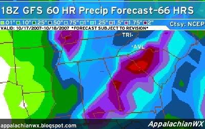
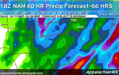
Widespread .50"+ totals are not out of the question...with scattered 1"+ totals possible.
Also, this system is going to kick up some dust...literally. Tonight, across the mountains and foothills, 30+ MPH gusts are possible, especially in the Smoky Mountains. Tomorrow, winds increase across the area, with gusts up to 25 MPH possible in the valleys.
10/17/07-10:16 PM
![]()

No comments:
Post a Comment